Before you head out to the graveyard that you intend to record, I want you to make a sketchmap to bring with you.
While the digital recording system that we are using can read the geolocation of your device when you are standing at a stone, the accuracy of that location might not be enough for us to understand any spatial patterns that might exist. While testing the system in a local graveyard, I found that stones a few feet apart would show up on the map (using my cellphone’s geolocation) hundreds of feet apart. It’s not very good resolution.
Normally, in archaeology, extremely careful surveying is done so that everything that is recorded or recovered has a precise location in three dimensional space, keyed in to larger systems of spatial organization. For obvious reasons, we can’t do that.
Instead, I want you to begin by making a sketch map of the graveyard. You might want to try using Google Earth Pro to see if you can find your graveyard; if you can, print out a screenshot and use that as the basis for your sketchmap and developing your recording scheme. It might be that where you live there is sufficient demand for high-resolution imagery that you can even make out individual stones. Where I live, that’s not the case.
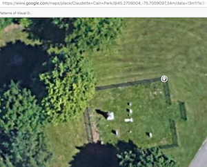
Here’s a screenshot from Google Maps of a cemetery in a park in the Riverside South part of Ottawa:
I have a simple paint program on my computer, and I used it to create this:
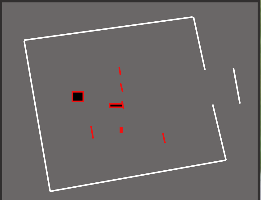
I could print that out on a single sheet of paper, and use that to indicate the various graves, which I would then number. - MCOO for the cemetery (Moodie Cemetery Ottawa Ontario), and mcoo-01, mcoo-02 for the graves. I could add more details as I found them - stones that aren’t visible in the satellite image, for instance.
The cemetery is surrounded by an ornamental fence. I could measure that, and indicate the lengths on this map. I could measure in from two sides to each stone, so that I know the distance and positioning of each stone.
If you number the stones on your sketch, then you can be sure you don’t miss any, and should someone else make use of your data, they will know which stones you are referring to.
If satellite imagery isn’t available, you could go to the graveyard, and simply sketch the terrain - indicate major features of the landscape, falls in the land, landmarks unlikely to change. Take measurements so that the position of the stones can be unambiguous.
The sketchmap is a tool to use when you’re out at the graveyard. It doesn’t have to be pretty. Feel free to take a quick snap of your sketchmap and share it in Discord. (Also, make sure to put it in your repo for this week too.)
(Later, you’ll try to make a digital map from your sketchmap. You might be able to work out coordinates for your stones between what your phone’s geolocation says, and what you can deduce from looking at Google Earth or Google Maps).